Coming Soon to (Google) Earth Near You
 In case you have never seen Google Earth, or have not run it in a while, be aware that this wonderful map / visualization / virtual travel program has become populated rapidly by the user community with three-dimensional models of famous structures. In other words, not only can you zoom around the country, viewing maps from any angle and any direction and quickly pinpoint interesting places on our earth, you now can also fly around a growing database of famous monuments, buildings, structures, and sites. In the New York/New Jersey area alone, you can see fascinating detailed models of the Brooklyn Bridge, the city of Newark, and downtown Manhattan. Soon to be added to this list of global importance, Union’s World’s Tallest Water Sphere.
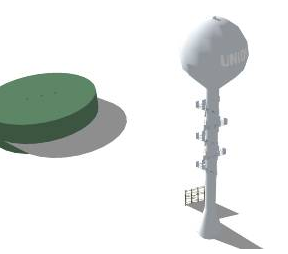
While waiting for the voting, you can preview the 3D model of the World’s Tallest Water Sphere. If you are a Google or SketchUp community member, please give it a good rating, so it appears in Google Earth. Note the wonderful modeling of the most recent white paint scheme, the multitude of cell phone antennas, the abandoned E-town billboard at its base, and the nearby green water tank.
This model has been painstakingly created by artist FlagFreak who has created many wonderful models in Google SketchUp. Using photos provided by this site, this Google user and WTWS has made a noteworthy contribution to virtual travellers everywhere.
We will post the Google Earth coordinates when the WTWS model goes public.